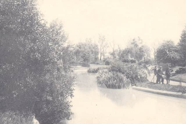
The lake that was fed by the Teville Stream


As Tony explained, the problem is that the culverts, which were built by Victorian engineers, were designed to comfortably accommodate the normal flow of the stream, but were not made large enough to cope with exceptionally heavy or prolonged rainfall.
Originally, of course, the Teville Stream ran open and unchecked, and in the early 19th century Teville Road was known as Vapours Lane, in reference to the mists that were prevalent on the low-lying marshy land along the stream.
Advertisement
Hide AdAdvertisement
Hide AdAs more and more of the farmland around Worthing was built over during the Victorian era, the Teville Stream was gradually culverted; and most of this process was complete by the time the Ordnance Survey map of 1896 was published.
The 1896 map shows the Teville Stream surfacing for the first time just south of the junction of Heene Road and Tarring Road, and then disappearing underground soon afterwards, just south-west of the sharp bend in Howard Street.
It resurfaced briefly just south of the main railway station, disappeared underground again just west of Broadwater Road, and reappeared east of Ladydell Road.
After this, the Teville Stream ran free and unculverted until it was joined by the Broadwater Brook, just south-east of East Worthing station. Then it flowed south to the sea.
Advertisement
Hide AdAdvertisement
Hide AdAs late as medieval times the Teville Stream and the Broadwater Brook had both been tidal inlets – indeed the latter was the “broad water” that gave the village its name – but the sea had retreated long before the start of the 19th century, when Jane Austen visited Worthing.
Later, she based the town of Sanditon in her final, unfinished novel on the geography of Worthing, “Old Sanditon” being her version of Broadwater; and she was almost certainly thinking of the Broadwater Brook when she wrote that “a branch only of the valley, winding more obliquely towards the sea, gave a passage to an inconsiderable stream”.
The culverting of the Teville Stream during the 19th century was not the only regrettable decision made in respect of its course – for further alterations eighty years ago led to the loss of the picturesque lake that for nearly half a century had been an attractive feature of Homefield Park.
According to Jack Watts in his 1982 book “Old Worthing As I Remember It, 1906-1920”, the lake was filled in because the section of the Teville Stream that fed it was piped out to Ham Bridge in 1934 when Chesswood Road was developed.
Advertisement
Hide AdAdvertisement
Hide AdHomefield Park, which opened in 1876, had been the first public park in Worthing – and indeed it remained the town’s only park until Lady Loder of Beach House presented Steyne Gardens to the town in 1900 and the Victoria Recreation Ground was opened the following year.
Known during its first few years as the People’s Park, Homefield Park was extended in 1881 and again in 1887; and it was in the latter year that the lake was created.
For the first century of its existence, the park was considerably larger than it is today, but the hospital encroached on some of the northern end from 1974 onwards.
The site of the old lake, however, has not been built upon. It is now a grassy area just north of the eastern end of Park Avenue.
Advertisement
Hide AdAdvertisement
Hide AdThe lake, which ran from west to east, was long and narrow, being about 100 yards in length and, at its widest point, about 30 yards across (north to south).
It was much visited by postcard photographers, particularly before the First World War, and all the old postcards reproduced here date from between 1904 and 1914.
Working out which photographs are of which sections of the lake is often far from easy, and a friend and I spent some two hours a couple of years ago painstakingly relating my 30 or so postcards of the lake to the map of 1896.
However, it was time well spent, since I am confident that all the “geography” in the captions is correct.
• Antony Edmonds is the author of Worthing: The Postcard Collection (Amberley, 2013).